|
|
|||||||||||||||||
| Point ID: 8516 | Downloads | Plots | Site Data | Code: 10531 |
|
|
|||||||||||||||||
| Download | |
|---|---|
| Site Descriptor Information | Site Time Series Data |
| Link to all available data | |
| View: | Time Series | All |
| Units: | mm |
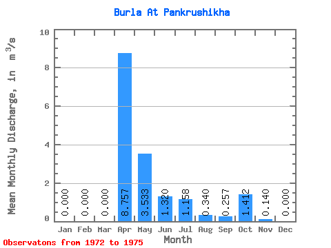
| Statistic | Jan | Feb | Mar | Apr | May | Jun | Jul | Aug | Sep | Oct | Nov | Dec | Annual |
|---|---|---|---|---|---|---|---|---|---|---|---|---|---|
| Mean | 0.00 | 0.00 | 0.00 | 8.76 | 3.53 | 1.32 | 1.16 | 0.34 | 0.26 | 1.41 | 0.14 | 0.00 | 1.16 |
| Standard Deviation | 0.00 | 0.00 | 0.00 | 10.26 | 3.41 | 1.01 | 1.58 | 0.63 | 0.50 | 2.82 | 0.28 | 0.00 | 1.27 |
| Min | 0.00 | 0.00 | 0.00 | 2.64 | 1.56 | 0.37 | 0.12 | 0.00 | 0.00 | 0.00 | 0.00 | 0.00 | 0.41 |
| Max | 0.00 | 0.00 | 0.00 | 20.60 | 7.47 | 2.50 | 3.46 | 1.29 | 1.01 | 5.64 | 0.56 | 0.00 | 2.62 |
| Coefficient of Variation | 1.17 | 0.96 | 0.77 | 1.36 | 1.86 | 1.95 | 2.00 | 2.00 | 1.10 |
 Return to R-Arctic Net Home Page