|
|
|||||||||||||||||
| Point ID: 8513 | Downloads | Plots | Site Data | Code: 10510 |
|
|
|||||||||||||||||
| Download | |
|---|---|
| Site Descriptor Information | Site Time Series Data |
| Link to all available data | |
| View: | Time Series | All |
| Units: | mm |
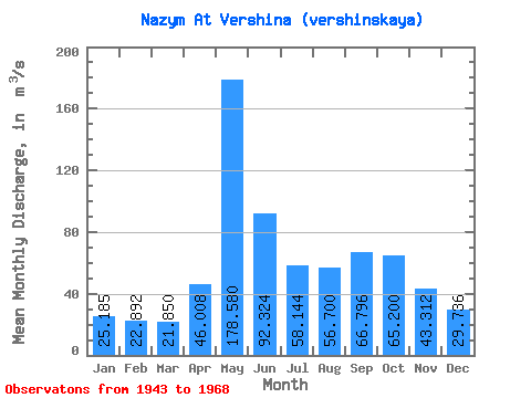
| Statistic | Jan | Feb | Mar | Apr | May | Jun | Jul | Aug | Sep | Oct | Nov | Dec | Annual |
|---|---|---|---|---|---|---|---|---|---|---|---|---|---|
| Mean | 25.18 | 22.89 | 21.85 | 46.01 | 178.58 | 92.32 | 58.14 | 56.70 | 66.80 | 65.20 | 43.31 | 29.74 | 58.89 |
| Standard Deviation | 4.78 | 4.29 | 3.22 | 28.29 | 54.08 | 29.21 | 17.36 | 41.35 | 31.05 | 27.46 | 11.97 | 7.31 | 11.20 |
| Min | 18.00 | 15.70 | 14.30 | 13.10 | 67.10 | 52.20 | 35.60 | 30.10 | 30.10 | 34.20 | 26.30 | 19.50 | 44.17 |
| Max | 37.20 | 32.70 | 26.70 | 122.00 | 265.00 | 171.00 | 110.00 | 223.00 | 173.00 | 149.00 | 64.00 | 44.90 | 93.53 |
| Coefficient of Variation | 0.19 | 0.19 | 0.15 | 0.61 | 0.30 | 0.32 | 0.30 | 0.73 | 0.47 | 0.42 | 0.28 | 0.25 | 0.19 |
 Return to R-Arctic Net Home Page