|
|
|||||||||||||||||
| Point ID: 8506 | Downloads | Plots | Site Data | Code: 10467 |
|
|
|||||||||||||||||
| Download | |
|---|---|
| Site Descriptor Information | Site Time Series Data |
| Link to all available data | |
| View: | Time Series | All |
| Units: | mm |
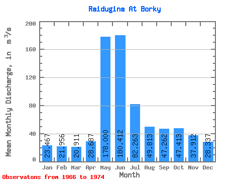
| Statistic | Jan | Feb | Mar | Apr | May | Jun | Jul | Aug | Sep | Oct | Nov | Dec | Annual |
|---|---|---|---|---|---|---|---|---|---|---|---|---|---|
| Mean | 23.47 | 21.96 | 20.91 | 28.69 | 178.00 | 180.41 | 82.26 | 49.81 | 47.26 | 47.41 | 37.91 | 28.34 | 62.03 |
| Standard Deviation | 5.45 | 4.43 | 3.98 | 7.40 | 69.65 | 73.26 | 30.20 | 12.65 | 15.15 | 14.93 | 11.04 | 7.38 | 12.90 |
| Min | 17.90 | 16.70 | 16.60 | 16.30 | 98.00 | 65.70 | 39.80 | 33.40 | 28.90 | 32.30 | 26.20 | 20.20 | 44.41 |
| Max | 32.10 | 28.80 | 27.70 | 38.10 | 300.00 | 244.00 | 136.00 | 66.20 | 73.20 | 74.30 | 58.80 | 40.60 | 83.39 |
| Coefficient of Variation | 0.23 | 0.20 | 0.19 | 0.26 | 0.39 | 0.41 | 0.37 | 0.25 | 0.32 | 0.32 | 0.29 | 0.26 | 0.21 |
 Return to R-Arctic Net Home Page