|
|
|||||||||||||||||
| Point ID: 8491 | Downloads | Plots | Site Data | Code: 10395 |
|
|
|||||||||||||||||
| Download | |
|---|---|
| Site Descriptor Information | Site Time Series Data |
| Link to all available data | |
| View: | Time Series | All |
| Units: | mm |
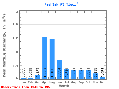
| Statistic | Jan | Feb | Mar | Apr | May | Jun | Jul | Aug | Sep | Oct | Nov | Dec | Annual |
|---|---|---|---|---|---|---|---|---|---|---|---|---|---|
| Mean | 0.04 | 0.04 | 0.13 | 1.23 | 1.17 | 0.55 | 0.31 | 0.27 | 0.27 | 0.27 | 0.17 | 0.06 | 0.36 |
| Standard Deviation | 0.02 | 0.02 | 0.24 | 0.52 | 0.64 | 0.41 | 0.20 | 0.20 | 0.19 | 0.20 | 0.12 | 0.03 | 0.11 |
| Min | 0.01 | 0.01 | 0.00 | 0.44 | 0.41 | 0.15 | 0.14 | 0.08 | 0.07 | 0.01 | 0.02 | 0.02 | 0.23 |
| Max | 0.07 | 0.07 | 0.87 | 2.27 | 2.52 | 1.23 | 0.75 | 0.81 | 0.80 | 0.80 | 0.52 | 0.13 | 0.56 |
| Coefficient of Variation | 0.44 | 0.59 | 1.88 | 0.42 | 0.55 | 0.74 | 0.62 | 0.74 | 0.70 | 0.74 | 0.69 | 0.55 | 0.32 |
 Return to R-Arctic Net Home Page