|
|
|||||||||||||||||
| Point ID: 8486 | Downloads | Plots | Site Data | Code: 10365 |
|
|
|||||||||||||||||
| Download | |
|---|---|
| Site Descriptor Information | Site Time Series Data |
| Link to all available data | |
| View: | Time Series | All |
| Units: | mm |
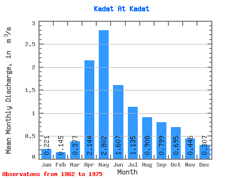
| Statistic | Jan | Feb | Mar | Apr | May | Jun | Jul | Aug | Sep | Oct | Nov | Dec | Annual |
|---|---|---|---|---|---|---|---|---|---|---|---|---|---|
| Mean | 0.22 | 0.14 | 0.38 | 2.14 | 2.80 | 1.61 | 1.14 | 0.91 | 0.80 | 0.69 | 0.45 | 0.31 | 0.96 |
| Standard Deviation | 0.14 | 0.10 | 0.40 | 1.52 | 2.81 | 1.02 | 0.72 | 0.44 | 0.26 | 0.21 | 0.19 | 0.14 | 0.42 |
| Min | 0.11 | 0.00 | 0.10 | 0.51 | 0.88 | 0.59 | 0.47 | 0.45 | 0.50 | 0.45 | 0.20 | 0.14 | 0.50 |
| Max | 0.60 | 0.43 | 1.40 | 5.50 | 11.30 | 3.50 | 2.82 | 1.84 | 1.44 | 1.20 | 0.88 | 0.68 | 1.85 |
| Coefficient of Variation | 0.63 | 0.72 | 1.06 | 0.71 | 1.00 | 0.64 | 0.63 | 0.48 | 0.32 | 0.31 | 0.42 | 0.47 | 0.44 |
 Return to R-Arctic Net Home Page