|
|
|||||||||||||||||
| Point ID: 8471 | Downloads | Plots | Site Data | Code: 10291 |
|
|
|||||||||||||||||
| Download | |
|---|---|
| Site Descriptor Information | Site Time Series Data |
| Link to all available data | |
| View: | Time Series | All |
| Units: | mm |
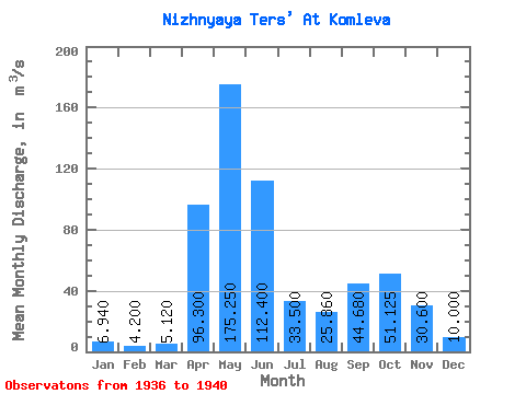
| Statistic | Jan | Feb | Mar | Apr | May | Jun | Jul | Aug | Sep | Oct | Nov | Dec | Annual |
|---|---|---|---|---|---|---|---|---|---|---|---|---|---|
| Mean | 6.94 | 4.20 | 5.12 | 96.30 | 175.25 | 112.40 | 33.50 | 25.86 | 44.68 | 51.12 | 30.60 | 10.00 | 37.38 |
| Standard Deviation | 29.05 | 71.46 | 17.14 | 17.99 | 18.42 | 27.78 | |||||||
| Min | 6.94 | 4.20 | 5.12 | 96.30 | 150.00 | 42.00 | 11.50 | 12.00 | 18.70 | 23.20 | 30.60 | 10.00 | 37.38 |
| Max | 6.94 | 4.20 | 5.12 | 96.30 | 216.00 | 206.00 | 53.00 | 56.10 | 67.50 | 89.40 | 30.60 | 10.00 | 37.38 |
| Coefficient of Variation | 0.17 | 0.64 | 0.51 | 0.70 | 0.41 | 0.54 |
 Return to R-Arctic Net Home Page