|
|
|||||||||||||||||
| Point ID: 8443 | Downloads | Plots | Site Data | Code: 10158 |
|
|
|||||||||||||||||
| Download | |
|---|---|
| Site Descriptor Information | Site Time Series Data |
| Link to all available data | |
| View: | Time Series | All |
| Units: | mm |
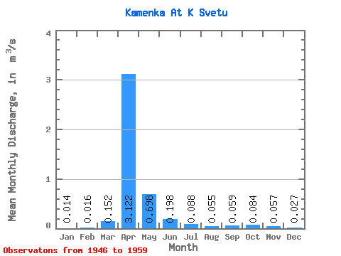
| Statistic | Jan | Feb | Mar | Apr | May | Jun | Jul | Aug | Sep | Oct | Nov | Dec | Annual |
|---|---|---|---|---|---|---|---|---|---|---|---|---|---|
| Mean | 0.01 | 0.02 | 0.15 | 3.12 | 0.70 | 0.20 | 0.09 | 0.06 | 0.06 | 0.08 | 0.06 | 0.03 | 0.39 |
| Standard Deviation | 0.01 | 0.02 | 0.23 | 2.41 | 0.40 | 0.20 | 0.08 | 0.05 | 0.06 | 0.08 | 0.04 | 0.02 | 0.23 |
| Min | 0.00 | 0.00 | 0.01 | 0.88 | 0.15 | 0.01 | 0.00 | 0.00 | 0.00 | 0.01 | 0.02 | 0.00 | 0.12 |
| Max | 0.04 | 0.06 | 0.74 | 9.55 | 1.33 | 0.62 | 0.23 | 0.16 | 0.20 | 0.29 | 0.12 | 0.09 | 0.97 |
| Coefficient of Variation | 1.04 | 1.28 | 1.50 | 0.77 | 0.57 | 1.01 | 0.91 | 0.91 | 1.05 | 0.96 | 0.64 | 0.92 | 0.60 |
 Return to R-Arctic Net Home Page