|
|
|||||||||||||||||
| Point ID: 8424 | Downloads | Plots | Site Data | Code: 10094 |
|
|
|||||||||||||||||
| Download | |
|---|---|
| Site Descriptor Information | Site Time Series Data |
| Link to all available data | |
| View: | Time Series | All |
| Units: | mm |
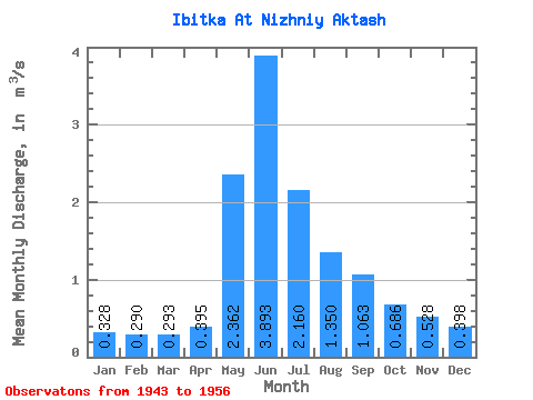
| Statistic | Jan | Feb | Mar | Apr | May | Jun | Jul | Aug | Sep | Oct | Nov | Dec | Annual |
|---|---|---|---|---|---|---|---|---|---|---|---|---|---|
| Mean | 0.33 | 0.29 | 0.29 | 0.40 | 2.36 | 3.89 | 2.16 | 1.35 | 1.06 | 0.69 | 0.53 | 0.40 | 1.16 |
| Standard Deviation | 0.10 | 0.08 | 0.06 | 0.20 | 1.87 | 2.73 | 1.19 | 0.24 | 0.34 | 0.28 | 0.17 | 0.11 | 0.34 |
| Min | 0.22 | 0.22 | 0.21 | 0.22 | 0.76 | 1.98 | 1.22 | 1.02 | 0.55 | 0.35 | 0.29 | 0.25 | 0.72 |
| Max | 0.46 | 0.40 | 0.34 | 0.67 | 4.71 | 7.83 | 3.74 | 1.53 | 1.30 | 1.08 | 0.73 | 0.52 | 1.47 |
| Coefficient of Variation | 0.30 | 0.27 | 0.20 | 0.51 | 0.79 | 0.70 | 0.55 | 0.18 | 0.33 | 0.41 | 0.32 | 0.27 | 0.29 |
 Return to R-Arctic Net Home Page