|
|
|||||||||||||||||
| Point ID: 8420 | Downloads | Plots | Site Data | Code: 10068 |
|
|
|||||||||||||||||
| Download | |
|---|---|
| Site Descriptor Information | Site Time Series Data |
| Link to all available data | |
| View: | Time Series | All |
| Units: | mm |
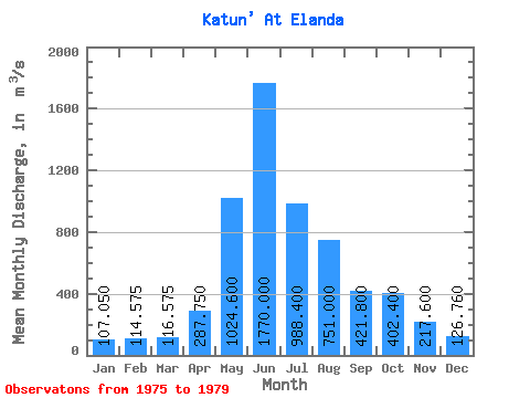
| Statistic | Jan | Feb | Mar | Apr | May | Jun | Jul | Aug | Sep | Oct | Nov | Dec | Annual |
|---|---|---|---|---|---|---|---|---|---|---|---|---|---|
| Mean | 107.05 | 114.58 | 116.58 | 287.75 | 1024.60 | 1770.00 | 988.40 | 751.00 | 421.80 | 402.40 | 217.60 | 126.76 | 511.82 |
| Standard Deviation | 26.98 | 27.09 | 19.96 | 112.19 | 252.11 | 694.23 | 123.58 | 108.03 | 78.72 | 98.59 | 61.14 | 32.27 | 53.59 |
| Min | 70.20 | 74.30 | 90.30 | 190.00 | 682.00 | 1230.00 | 840.00 | 673.00 | 334.00 | 274.00 | 160.00 | 90.00 | 447.48 |
| Max | 134.00 | 133.00 | 134.00 | 410.00 | 1330.00 | 2950.00 | 1140.00 | 938.00 | 518.00 | 538.00 | 305.00 | 166.00 | 569.50 |
| Coefficient of Variation | 0.25 | 0.24 | 0.17 | 0.39 | 0.25 | 0.39 | 0.12 | 0.14 | 0.19 | 0.24 | 0.28 | 0.26 | 0.10 |
 Return to R-Arctic Net Home Page