|
|
|||||||||||||||||
| Point ID: 8395 | Downloads | Plots | Site Data | Code: 9492 |
|
|
|||||||||||||||||
| Download | |
|---|---|
| Site Descriptor Information | Site Time Series Data |
| Link to all available data | |
| View: | Time Series | All |
| Units: | mm |
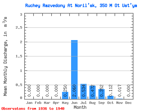
| Statistic | Jan | Feb | Mar | Apr | May | Jun | Jul | Aug | Sep | Oct | Nov | Dec | Annual |
|---|---|---|---|---|---|---|---|---|---|---|---|---|---|
| Mean | 0.00 | 0.00 | 0.00 | 0.00 | 0.25 | 2.06 | 0.53 | 0.47 | 0.35 | 0.11 | 0.02 | 0.00 | 0.32 |
| Standard Deviation | 0.00 | 0.00 | 0.00 | 0.00 | 0.42 | 0.34 | 0.23 | 0.24 | 0.20 | 0.05 | 0.02 | 0.00 | 0.08 |
| Min | 0.00 | 0.00 | 0.00 | 0.00 | 0.00 | 1.81 | 0.34 | 0.20 | 0.17 | 0.05 | 0.00 | 0.00 | 0.22 |
| Max | 0.00 | 0.00 | 0.00 | 0.00 | 0.88 | 2.54 | 0.86 | 0.85 | 0.65 | 0.18 | 0.05 | 0.00 | 0.42 |
| Coefficient of Variation | 1.69 | 0.16 | 0.42 | 0.51 | 0.56 | 0.43 | 1.31 | 0.25 |
 Return to R-Arctic Net Home Page