|
|
|||||||||||||||||
| Point ID: 8369 | Downloads | Plots | Site Data | Code: 9398 |
|
|
|||||||||||||||||
| Download | |
|---|---|
| Site Descriptor Information | Site Time Series Data |
| Link to all available data | |
| View: | Time Series | All |
| Units: | mm |
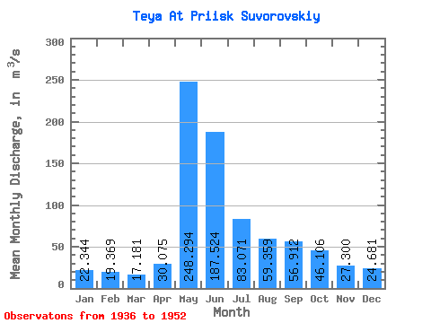
| Statistic | Jan | Feb | Mar | Apr | May | Jun | Jul | Aug | Sep | Oct | Nov | Dec | Annual |
|---|---|---|---|---|---|---|---|---|---|---|---|---|---|
| Mean | 22.34 | 19.37 | 17.18 | 30.07 | 248.29 | 187.52 | 83.07 | 59.36 | 56.91 | 46.11 | 27.30 | 24.68 | 68.31 |
| Standard Deviation | 2.85 | 2.93 | 6.64 | 17.29 | 32.90 | 69.92 | 24.96 | 13.26 | 14.75 | 13.80 | 9.07 | 3.64 | 7.93 |
| Min | 19.00 | 16.00 | 12.20 | 18.80 | 206.00 | 87.90 | 48.80 | 46.30 | 42.50 | 23.20 | 18.40 | 20.00 | 58.13 |
| Max | 30.80 | 28.20 | 41.10 | 86.60 | 332.00 | 376.00 | 130.00 | 93.20 | 93.70 | 68.80 | 48.30 | 33.00 | 84.58 |
| Coefficient of Variation | 0.13 | 0.15 | 0.39 | 0.57 | 0.13 | 0.37 | 0.30 | 0.22 | 0.26 | 0.30 | 0.33 | 0.15 | 0.12 |
 Return to R-Arctic Net Home Page