|
|
|||||||||||||||||
| Point ID: 8367 | Downloads | Plots | Site Data | Code: 9395 |
|
|
|||||||||||||||||
| Download | |
|---|---|
| Site Descriptor Information | Site Time Series Data |
| Link to all available data | |
| View: | Time Series | All |
| Units: | mm |
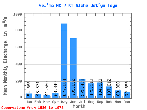
| Statistic | Jan | Feb | Mar | Apr | May | Jun | Jul | Aug | Sep | Oct | Nov | Dec | Annual |
|---|---|---|---|---|---|---|---|---|---|---|---|---|---|
| Mean | 54.87 | 45.57 | 41.65 | 63.84 | 877.68 | 703.69 | 225.48 | 173.91 | 184.12 | 137.81 | 89.88 | 72.86 | 224.91 |
| Standard Deviation | 16.64 | 13.95 | 12.12 | 49.46 | 203.02 | 291.54 | 81.65 | 85.86 | 86.49 | 60.47 | 29.18 | 23.32 | 43.25 |
| Min | 18.40 | 12.40 | 11.00 | 25.80 | 441.00 | 323.00 | 83.10 | 83.70 | 85.30 | 58.80 | 30.70 | 33.20 | 164.57 |
| Max | 90.30 | 74.00 | 67.30 | 294.00 | 1360.00 | 1790.00 | 450.00 | 404.00 | 400.00 | 336.00 | 185.00 | 137.00 | 339.46 |
| Coefficient of Variation | 0.30 | 0.31 | 0.29 | 0.78 | 0.23 | 0.41 | 0.36 | 0.49 | 0.47 | 0.44 | 0.33 | 0.32 | 0.19 |
 Return to R-Arctic Net Home Page