|
|
|||||||||||||||||
| Point ID: 8365 | Downloads | Plots | Site Data | Code: 9383 |
|
|
|||||||||||||||||
| Download | |
|---|---|
| Site Descriptor Information | Site Time Series Data |
| Link to all available data | |
| View: | Time Series | All |
| Units: | mm |
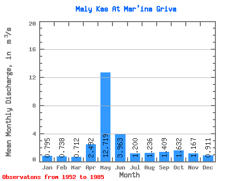
| Statistic | Jan | Feb | Mar | Apr | May | Jun | Jul | Aug | Sep | Oct | Nov | Dec | Annual |
|---|---|---|---|---|---|---|---|---|---|---|---|---|---|
| Mean | 0.80 | 0.74 | 0.71 | 2.49 | 12.72 | 3.96 | 1.20 | 1.24 | 1.41 | 1.63 | 1.17 | 0.91 | 2.41 |
| Standard Deviation | 0.12 | 0.13 | 0.12 | 2.33 | 5.18 | 2.12 | 0.55 | 0.72 | 0.83 | 0.77 | 0.41 | 0.20 | 0.58 |
| Min | 0.58 | 0.48 | 0.43 | 0.56 | 3.20 | 1.36 | 0.60 | 0.41 | 0.64 | 0.66 | 0.58 | 0.59 | 1.18 |
| Max | 1.06 | 1.09 | 1.09 | 9.32 | 25.10 | 9.46 | 2.90 | 3.15 | 3.86 | 3.36 | 2.32 | 1.34 | 3.63 |
| Coefficient of Variation | 0.16 | 0.17 | 0.17 | 0.94 | 0.41 | 0.54 | 0.46 | 0.58 | 0.59 | 0.47 | 0.35 | 0.22 | 0.24 |
 Return to R-Arctic Net Home Page