|
|
|||||||||||||||||
| Point ID: 8361 | Downloads | Plots | Site Data | Code: 9364 |
|
|
|||||||||||||||||
| Download | |
|---|---|
| Site Descriptor Information | Site Time Series Data |
| Link to all available data | |
| View: | Time Series | All |
| Units: | mm |
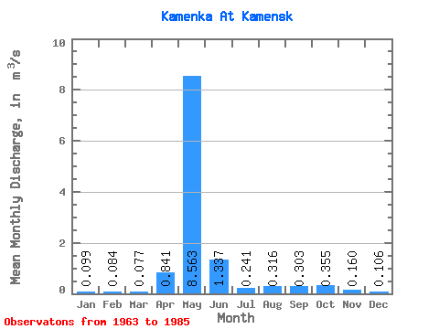
| Statistic | Jan | Feb | Mar | Apr | May | Jun | Jul | Aug | Sep | Oct | Nov | Dec | Annual |
|---|---|---|---|---|---|---|---|---|---|---|---|---|---|
| Mean | 0.10 | 0.08 | 0.08 | 0.84 | 8.56 | 1.34 | 0.24 | 0.32 | 0.30 | 0.35 | 0.16 | 0.11 | 1.04 |
| Standard Deviation | 0.06 | 0.05 | 0.04 | 1.25 | 3.08 | 1.19 | 0.13 | 0.24 | 0.15 | 0.20 | 0.07 | 0.05 | 0.30 |
| Min | 0.00 | 0.00 | 0.00 | 0.00 | 1.62 | 0.36 | 0.07 | 0.06 | 0.09 | 0.09 | 0.02 | 0.00 | 0.40 |
| Max | 0.27 | 0.22 | 0.14 | 3.94 | 13.40 | 5.53 | 0.65 | 1.00 | 0.65 | 0.87 | 0.27 | 0.19 | 1.48 |
| Coefficient of Variation | 0.59 | 0.63 | 0.54 | 1.48 | 0.36 | 0.89 | 0.55 | 0.76 | 0.49 | 0.56 | 0.45 | 0.47 | 0.29 |
 Return to R-Arctic Net Home Page