|
|
|||||||||||||||||
| Point ID: 8357 | Downloads | Plots | Site Data | Code: 9350 |
|
|
|||||||||||||||||
| Download | |
|---|---|
| Site Descriptor Information | Site Time Series Data |
| Link to all available data | |
| View: | Time Series | All |
| Units: | mm |
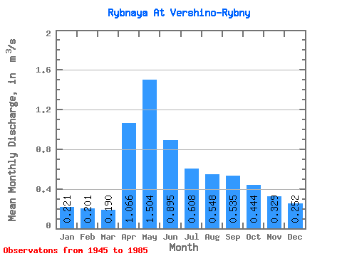
| Statistic | Jan | Feb | Mar | Apr | May | Jun | Jul | Aug | Sep | Oct | Nov | Dec | Annual |
|---|---|---|---|---|---|---|---|---|---|---|---|---|---|
| Mean | 0.22 | 0.20 | 0.19 | 1.07 | 1.50 | 0.90 | 0.61 | 0.55 | 0.54 | 0.44 | 0.33 | 0.25 | 0.57 |
| Standard Deviation | 0.10 | 0.08 | 0.06 | 0.53 | 0.75 | 0.45 | 0.33 | 0.33 | 0.39 | 0.27 | 0.18 | 0.10 | 0.17 |
| Min | 0.07 | 0.07 | 0.11 | 0.25 | 0.28 | 0.26 | 0.18 | 0.13 | 0.12 | 0.12 | 0.09 | 0.08 | 0.27 |
| Max | 0.54 | 0.43 | 0.36 | 2.36 | 4.07 | 2.77 | 1.62 | 1.51 | 2.18 | 1.68 | 1.05 | 0.54 | 0.99 |
| Coefficient of Variation | 0.43 | 0.40 | 0.33 | 0.50 | 0.50 | 0.50 | 0.55 | 0.60 | 0.73 | 0.61 | 0.56 | 0.38 | 0.31 |
 Return to R-Arctic Net Home Page