|
|
|||||||||||||||||
| Point ID: 8347 | Downloads | Plots | Site Data | Code: 9311 |
|
|
|||||||||||||||||
| Download | |
|---|---|
| Site Descriptor Information | Site Time Series Data |
| Link to all available data | |
| View: | Time Series | All |
| Units: | mm |
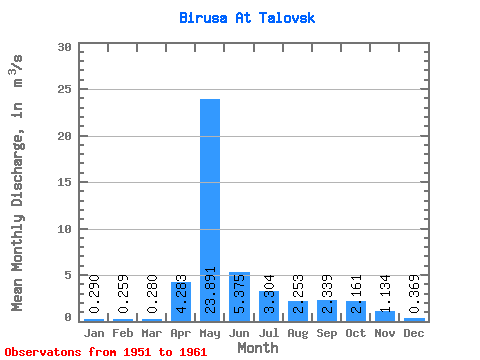
| Statistic | Jan | Feb | Mar | Apr | May | Jun | Jul | Aug | Sep | Oct | Nov | Dec | Annual |
|---|---|---|---|---|---|---|---|---|---|---|---|---|---|
| Mean | 0.29 | 0.26 | 0.28 | 4.28 | 23.89 | 5.38 | 3.30 | 2.25 | 2.34 | 2.16 | 1.13 | 0.37 | 3.76 |
| Standard Deviation | 0.10 | 0.09 | 0.13 | 4.31 | 4.35 | 3.57 | 2.45 | 1.94 | 2.13 | 1.72 | 1.17 | 0.11 | 0.67 |
| Min | 0.10 | 0.08 | 0.09 | 0.37 | 18.90 | 1.52 | 0.73 | 0.69 | 0.70 | 0.67 | 0.27 | 0.16 | 2.92 |
| Max | 0.45 | 0.37 | 0.54 | 14.30 | 34.50 | 12.90 | 7.44 | 7.16 | 7.51 | 5.66 | 4.23 | 0.53 | 5.01 |
| Coefficient of Variation | 0.35 | 0.34 | 0.48 | 1.00 | 0.18 | 0.66 | 0.74 | 0.86 | 0.91 | 0.79 | 1.03 | 0.30 | 0.18 |
 Return to R-Arctic Net Home Page