|
|
|||||||||||||||||
| Point ID: 8317 | Downloads | Plots | Site Data | Code: 9223 |
|
|
|||||||||||||||||
| Download | |
|---|---|
| Site Descriptor Information | Site Time Series Data |
| Link to all available data | |
| View: | Time Series | All |
| Units: | mm |
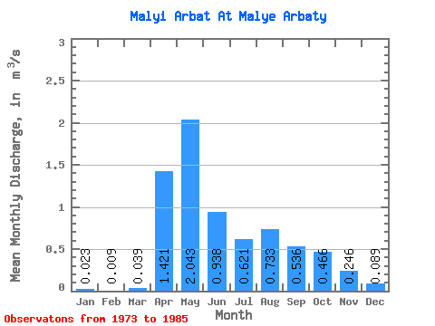
| Statistic | Jan | Feb | Mar | Apr | May | Jun | Jul | Aug | Sep | Oct | Nov | Dec | Annual |
|---|---|---|---|---|---|---|---|---|---|---|---|---|---|
| Mean | 0.02 | 0.01 | 0.04 | 1.42 | 2.04 | 0.94 | 0.62 | 0.73 | 0.54 | 0.47 | 0.25 | 0.09 | 0.60 |
| Standard Deviation | 0.04 | 0.02 | 0.05 | 0.85 | 0.71 | 0.58 | 0.66 | 0.84 | 0.40 | 0.26 | 0.16 | 0.12 | 0.23 |
| Min | 0.00 | 0.00 | 0.00 | 0.30 | 0.68 | 0.24 | 0.10 | 0.07 | 0.15 | 0.15 | 0.04 | 0.00 | 0.23 |
| Max | 0.10 | 0.07 | 0.16 | 3.39 | 2.92 | 2.18 | 2.24 | 2.91 | 1.40 | 0.98 | 0.59 | 0.44 | 1.08 |
| Coefficient of Variation | 1.65 | 2.30 | 1.22 | 0.60 | 0.35 | 0.62 | 1.06 | 1.15 | 0.74 | 0.55 | 0.67 | 1.34 | 0.39 |
 Return to R-Arctic Net Home Page