|
|
|||||||||||||||||
| Point ID: 8295 | Downloads | Plots | Site Data | Code: 9144 |
|
|
|||||||||||||||||
| Download | |
|---|---|
| Site Descriptor Information | Site Time Series Data |
| Link to all available data | |
| View: | Time Series | All |
| Units: | mm |
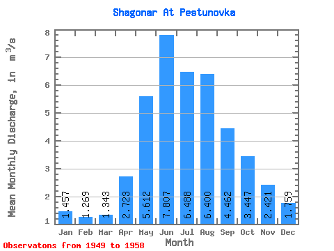
| Statistic | Jan | Feb | Mar | Apr | May | Jun | Jul | Aug | Sep | Oct | Nov | Dec | Annual |
|---|---|---|---|---|---|---|---|---|---|---|---|---|---|
| Mean | 1.46 | 1.27 | 1.34 | 2.72 | 5.61 | 7.81 | 6.49 | 6.40 | 4.46 | 3.45 | 2.42 | 1.76 | 3.72 |
| Standard Deviation | 0.31 | 0.19 | 0.20 | 0.99 | 2.99 | 5.84 | 3.12 | 2.06 | 1.14 | 0.49 | 0.51 | 0.27 | 0.72 |
| Min | 0.97 | 0.90 | 1.08 | 1.77 | 3.05 | 2.98 | 3.50 | 4.82 | 3.11 | 2.84 | 1.74 | 1.33 | 2.97 |
| Max | 1.95 | 1.53 | 1.68 | 4.95 | 12.80 | 20.00 | 12.50 | 11.30 | 6.24 | 4.40 | 3.13 | 2.23 | 4.92 |
| Coefficient of Variation | 0.21 | 0.15 | 0.15 | 0.36 | 0.53 | 0.75 | 0.48 | 0.32 | 0.26 | 0.14 | 0.21 | 0.15 | 0.20 |
 Return to R-Arctic Net Home Page