|
|
|||||||||||||||||
| Point ID: 8289 | Downloads | Plots | Site Data | Code: 9126 |
|
|
|||||||||||||||||
| Download | |
|---|---|
| Site Descriptor Information | Site Time Series Data |
| Link to all available data | |
| View: | Time Series | All |
| Units: | mm |
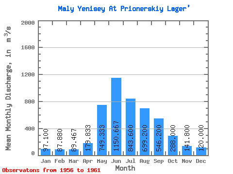
| Statistic | Jan | Feb | Mar | Apr | May | Jun | Jul | Aug | Sep | Oct | Nov | Dec | Annual |
|---|---|---|---|---|---|---|---|---|---|---|---|---|---|
| Mean | 97.10 | 87.88 | 89.47 | 179.83 | 749.33 | 1150.67 | 843.60 | 699.20 | 546.20 | 288.00 | 141.80 | 120.00 | 412.11 |
| Standard Deviation | 15.54 | 17.51 | 11.75 | 64.03 | 140.99 | 208.45 | 243.22 | 201.74 | 97.25 | 22.80 | 16.99 | 7.11 | 69.60 |
| Min | 74.40 | 63.50 | 70.10 | 137.00 | 596.00 | 910.00 | 477.00 | 471.00 | 412.00 | 265.00 | 123.00 | 112.00 | 327.14 |
| Max | 111.00 | 104.00 | 103.00 | 308.00 | 942.00 | 1480.00 | 1150.00 | 995.00 | 686.00 | 313.00 | 157.00 | 131.00 | 479.72 |
| Coefficient of Variation | 0.16 | 0.20 | 0.13 | 0.36 | 0.19 | 0.18 | 0.29 | 0.29 | 0.18 | 0.08 | 0.12 | 0.06 | 0.17 |
 Return to R-Arctic Net Home Page