|
|
|||||||||||||||||
| Point ID: 8277 | Downloads | Plots | Site Data | Code: 8403 |
|
|
|||||||||||||||||
| Download | |
|---|---|
| Site Descriptor Information | Site Time Series Data |
| Link to all available data | |
| View: | Time Series | All |
| Units: | mm |
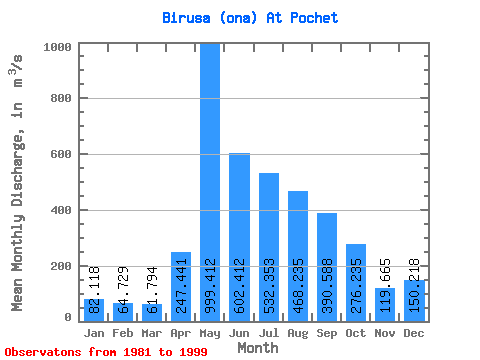
| Statistic | Jan | Feb | Mar | Apr | May | Jun | Jul | Aug | Sep | Oct | Nov | Dec | Annual |
|---|---|---|---|---|---|---|---|---|---|---|---|---|---|
| Mean | 82.12 | 64.73 | 61.79 | 247.44 | 999.41 | 602.41 | 532.35 | 468.24 | 390.59 | 276.24 | 119.67 | 150.22 | 332.93 |
| Standard Deviation | 15.42 | 13.26 | 9.17 | 179.33 | 440.51 | 186.10 | 254.68 | 231.60 | 135.50 | 74.14 | 25.87 | 199.80 | 82.75 |
| Min | 51.10 | 39.90 | 43.10 | 78.60 | 363.00 | 289.00 | 213.00 | 246.00 | 214.00 | 181.00 | 75.40 | 73.00 | 173.24 |
| Max | 105.00 | 88.10 | 76.60 | 680.00 | 2100.00 | 1020.00 | 1290.00 | 1120.00 | 679.00 | 450.00 | 150.00 | 922.00 | 524.87 |
| Coefficient of Variation | 0.19 | 0.20 | 0.15 | 0.72 | 0.44 | 0.31 | 0.48 | 0.49 | 0.35 | 0.27 | 0.22 | 1.33 | 0.25 |
 Return to R-Arctic Net Home Page