|
|
|||||||||||||||||
| Point ID: 8269 | Downloads | Plots | Site Data | Code: 8385 |
|
|
|||||||||||||||||
| Download | |
|---|---|
| Site Descriptor Information | Site Time Series Data |
| Link to all available data | |
| View: | Time Series | All |
| Units: | mm |
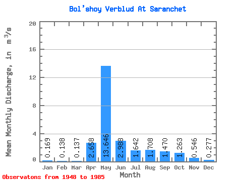
| Statistic | Jan | Feb | Mar | Apr | May | Jun | Jul | Aug | Sep | Oct | Nov | Dec | Annual |
|---|---|---|---|---|---|---|---|---|---|---|---|---|---|
| Mean | 0.17 | 0.14 | 0.14 | 2.66 | 13.65 | 2.99 | 1.64 | 1.71 | 1.47 | 1.26 | 0.55 | 0.28 | 2.22 |
| Standard Deviation | 0.09 | 0.07 | 0.09 | 3.36 | 4.75 | 1.30 | 1.09 | 1.78 | 1.57 | 0.88 | 0.31 | 0.16 | 0.52 |
| Min | 0.07 | 0.03 | 0.01 | 0.06 | 4.33 | 1.78 | 0.63 | 0.40 | 0.46 | 0.47 | 0.21 | 0.09 | 1.35 |
| Max | 0.40 | 0.30 | 0.32 | 12.90 | 23.70 | 7.25 | 4.94 | 8.07 | 8.43 | 3.81 | 1.23 | 0.74 | 3.14 |
| Coefficient of Variation | 0.53 | 0.54 | 0.63 | 1.26 | 0.35 | 0.43 | 0.67 | 1.04 | 1.07 | 0.69 | 0.56 | 0.59 | 0.23 |
 Return to R-Arctic Net Home Page