|
|
|||||||||||||||||
| Point ID: 8265 | Downloads | Plots | Site Data | Code: 8376 |
|
|
|||||||||||||||||
| Download | |
|---|---|
| Site Descriptor Information | Site Time Series Data |
| Link to all available data | |
| View: | Time Series | All |
| Units: | mm |
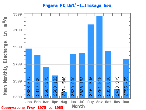
| Statistic | Jan | Feb | Mar | Apr | May | Jun | Jul | Aug | Sep | Oct | Nov | Dec | Annual |
|---|---|---|---|---|---|---|---|---|---|---|---|---|---|
| Mean | 2883.64 | 2810.00 | 2667.27 | 2568.18 | 2374.55 | 2820.00 | 2828.18 | 3164.55 | 3261.82 | 2850.00 | 2410.91 | 2755.45 | 2782.88 |
| Standard Deviation | 702.73 | 749.15 | 790.75 | 786.00 | 437.80 | 94.34 | 177.98 | 577.33 | 726.32 | 392.96 | 723.50 | 698.43 | 446.14 |
| Min | 1750.00 | 1630.00 | 1490.00 | 1100.00 | 1550.00 | 2710.00 | 2570.00 | 2660.00 | 2660.00 | 2300.00 | 1450.00 | 1560.00 | 2092.50 |
| Max | 4060.00 | 4050.00 | 4030.00 | 3750.00 | 3000.00 | 3040.00 | 3220.00 | 4430.00 | 5170.00 | 3530.00 | 3590.00 | 3570.00 | 3686.67 |
| Coefficient of Variation | 0.24 | 0.27 | 0.30 | 0.31 | 0.18 | 0.03 | 0.06 | 0.18 | 0.22 | 0.14 | 0.30 | 0.25 | 0.16 |
 Return to R-Arctic Net Home Page