|
|
|||||||||||||||||
| Point ID: 8243 | Downloads | Plots | Site Data | Code: 8316 |
|
|
|||||||||||||||||
| Download | |
|---|---|
| Site Descriptor Information | Site Time Series Data |
| Link to all available data | |
| View: | Time Series | All |
| Units: | mm |
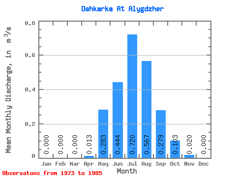
| Statistic | Jan | Feb | Mar | Apr | May | Jun | Jul | Aug | Sep | Oct | Nov | Dec | Annual |
|---|---|---|---|---|---|---|---|---|---|---|---|---|---|
| Mean | 0.00 | 0.00 | 0.00 | 0.01 | 0.28 | 0.44 | 0.72 | 0.57 | 0.28 | 0.10 | 0.02 | 0.00 | 0.20 |
| Standard Deviation | 0.00 | 0.00 | 0.00 | 0.01 | 0.17 | 0.18 | 0.76 | 0.34 | 0.26 | 0.08 | 0.02 | 0.00 | 0.12 |
| Min | 0.00 | 0.00 | 0.00 | 0.00 | 0.12 | 0.24 | 0.02 | 0.17 | 0.05 | 0.02 | 0.00 | 0.00 | 0.10 |
| Max | 0.00 | 0.00 | 0.01 | 0.05 | 0.68 | 0.86 | 2.66 | 1.14 | 0.98 | 0.32 | 0.05 | 0.01 | 0.52 |
| Coefficient of Variation | 3.46 | 1.11 | 0.60 | 0.41 | 1.05 | 0.60 | 0.94 | 0.82 | 0.94 | 3.61 | 0.61 |
 Return to R-Arctic Net Home Page