|
|
|||||||||||||||||
| Point ID: 8240 | Downloads | Plots | Site Data | Code: 8313 |
|
|
|||||||||||||||||
| Download | |
|---|---|
| Site Descriptor Information | Site Time Series Data |
| Link to all available data | |
| View: | Time Series | All |
| Units: | mm |
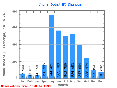
| Statistic | Jan | Feb | Mar | Apr | May | Jun | Jul | Aug | Sep | Oct | Nov | Dec | Annual |
|---|---|---|---|---|---|---|---|---|---|---|---|---|---|
| Mean | 57.93 | 47.31 | 44.15 | 156.40 | 744.42 | 563.79 | 503.79 | 524.05 | 397.68 | 238.47 | 97.45 | 78.24 | 285.40 |
| Standard Deviation | 16.72 | 13.36 | 11.84 | 123.58 | 209.44 | 140.48 | 172.93 | 195.38 | 121.73 | 64.17 | 25.45 | 17.56 | 49.37 |
| Min | 25.60 | 19.20 | 22.90 | 27.30 | 343.00 | 323.00 | 302.00 | 289.00 | 230.00 | 152.00 | 48.60 | 45.90 | 226.04 |
| Max | 86.60 | 69.50 | 61.30 | 468.00 | 1110.00 | 817.00 | 924.00 | 1090.00 | 624.00 | 406.00 | 156.00 | 109.00 | 383.52 |
| Coefficient of Variation | 0.29 | 0.28 | 0.27 | 0.79 | 0.28 | 0.25 | 0.34 | 0.37 | 0.31 | 0.27 | 0.26 | 0.22 | 0.17 |
 Return to R-Arctic Net Home Page