|
|
|||||||||||||||||
| Point ID: 8237 | Downloads | Plots | Site Data | Code: 8293 |
|
|
|||||||||||||||||
| Download | |
|---|---|
| Site Descriptor Information | Site Time Series Data |
| Link to all available data | |
| View: | Time Series | All |
| Units: | mm |
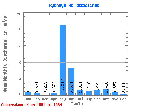
| Statistic | Jan | Feb | Mar | Apr | May | Jun | Jul | Aug | Sep | Oct | Nov | Dec | Annual |
|---|---|---|---|---|---|---|---|---|---|---|---|---|---|
| Mean | 0.79 | 0.53 | 0.23 | 0.62 | 17.01 | 6.59 | 1.33 | 1.20 | 1.28 | 1.44 | 0.90 | 0.34 | 2.72 |
| Standard Deviation | 1.49 | 0.91 | 0.12 | 0.38 | 4.41 | 2.96 | 2.38 | 0.72 | 0.93 | 0.82 | 0.57 | 0.41 | 0.83 |
| Min | 0.09 | 0.09 | 0.06 | 0.17 | 8.95 | 2.27 | -6.54 | 0.50 | 0.36 | 0.60 | 0.32 | -0.61 | 1.36 |
| Max | 5.00 | 3.10 | 0.37 | 1.43 | 24.60 | 13.70 | 3.18 | 3.09 | 3.62 | 2.96 | 2.05 | 0.89 | 3.85 |
| Coefficient of Variation | 1.88 | 1.71 | 0.50 | 0.61 | 0.26 | 0.45 | 1.79 | 0.60 | 0.72 | 0.57 | 0.64 | 1.21 | 0.30 |
 Return to R-Arctic Net Home Page