|
|
|||||||||||||||||
| Point ID: 8236 | Downloads | Plots | Site Data | Code: 8285 |
|
|
|||||||||||||||||
| Download | |
|---|---|
| Site Descriptor Information | Site Time Series Data |
| Link to all available data | |
| View: | Time Series | All |
| Units: | mm |
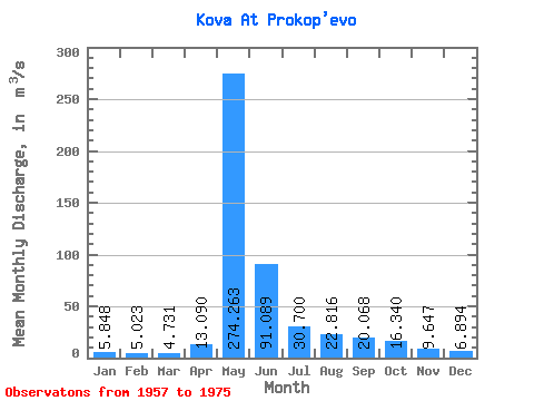
| Statistic | Jan | Feb | Mar | Apr | May | Jun | Jul | Aug | Sep | Oct | Nov | Dec | Annual |
|---|---|---|---|---|---|---|---|---|---|---|---|---|---|
| Mean | 5.85 | 5.02 | 4.73 | 13.09 | 274.26 | 91.09 | 30.70 | 22.82 | 20.07 | 16.34 | 9.65 | 6.89 | 41.71 |
| Standard Deviation | 1.99 | 1.74 | 1.91 | 11.68 | 71.49 | 48.57 | 12.68 | 11.67 | 10.40 | 5.86 | 3.67 | 2.06 | 9.08 |
| Min | 2.58 | 1.91 | 1.81 | 2.57 | 171.00 | 32.70 | 16.60 | 11.40 | 9.90 | 8.16 | 4.69 | 3.49 | 26.59 |
| Max | 9.75 | 8.90 | 8.98 | 37.60 | 433.00 | 212.00 | 56.00 | 53.70 | 53.80 | 31.40 | 20.50 | 11.10 | 53.91 |
| Coefficient of Variation | 0.34 | 0.35 | 0.41 | 0.89 | 0.26 | 0.53 | 0.41 | 0.51 | 0.52 | 0.36 | 0.38 | 0.30 | 0.22 |
 Return to R-Arctic Net Home Page