|
|
|||||||||||||||||
| Point ID: 8224 | Downloads | Plots | Site Data | Code: 8267 |
|
|
|||||||||||||||||
| Download | |
|---|---|
| Site Descriptor Information | Site Time Series Data |
| Link to all available data | |
| View: | Time Series | All |
| Units: | mm |
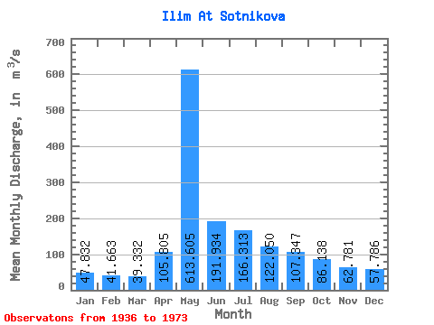
| Statistic | Jan | Feb | Mar | Apr | May | Jun | Jul | Aug | Sep | Oct | Nov | Dec | Annual |
|---|---|---|---|---|---|---|---|---|---|---|---|---|---|
| Mean | 47.83 | 41.66 | 39.33 | 105.81 | 613.61 | 191.93 | 166.31 | 122.05 | 107.35 | 86.14 | 62.78 | 57.79 | 136.17 |
| Standard Deviation | 9.49 | 9.38 | 9.02 | 86.96 | 201.16 | 68.45 | 73.15 | 32.13 | 26.76 | 19.98 | 14.82 | 11.69 | 24.45 |
| Min | 28.40 | 24.10 | 21.60 | 35.90 | 170.00 | 57.40 | 49.80 | 48.50 | 49.20 | 40.40 | 28.40 | 33.90 | 63.42 |
| Max | 67.70 | 62.40 | 56.80 | 356.00 | 1050.00 | 339.00 | 345.00 | 194.00 | 169.00 | 124.00 | 98.40 | 84.40 | 173.42 |
| Coefficient of Variation | 0.20 | 0.23 | 0.23 | 0.82 | 0.33 | 0.36 | 0.44 | 0.26 | 0.25 | 0.23 | 0.24 | 0.20 | 0.18 |
 Return to R-Arctic Net Home Page