|
|
|||||||||||||||||
| Point ID: 8192 | Downloads | Plots | Site Data | Code: 8180 |
|
|
|||||||||||||||||
| Download | |
|---|---|
| Site Descriptor Information | Site Time Series Data |
| Link to all available data | |
| View: | Time Series | All |
| Units: | mm |
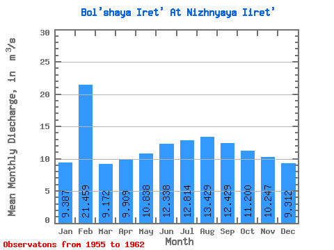
| Statistic | Jan | Feb | Mar | Apr | May | Jun | Jul | Aug | Sep | Oct | Nov | Dec | Annual |
|---|---|---|---|---|---|---|---|---|---|---|---|---|---|
| Mean | 9.39 | 21.46 | 9.17 | 9.91 | 10.84 | 12.34 | 12.81 | 13.43 | 12.43 | 11.20 | 10.25 | 9.31 | 10.88 |
| Standard Deviation | 1.03 | 32.06 | 1.45 | 1.63 | 0.48 | 0.82 | 0.68 | 1.14 | 0.96 | 0.94 | 1.16 | 0.78 | 0.57 |
| Min | 7.67 | 6.78 | 7.17 | 8.11 | 10.10 | 11.40 | 11.70 | 11.90 | 11.20 | 10.00 | 8.96 | 8.27 | 10.16 |
| Max | 10.50 | 94.10 | 11.30 | 13.20 | 11.70 | 14.00 | 13.90 | 14.90 | 14.00 | 12.70 | 11.60 | 10.60 | 11.52 |
| Coefficient of Variation | 0.11 | 1.49 | 0.16 | 0.16 | 0.04 | 0.07 | 0.05 | 0.09 | 0.08 | 0.08 | 0.11 | 0.08 | 0.05 |
 Return to R-Arctic Net Home Page