|
|
|||||||||||||||||
| Point ID: 8190 | Downloads | Plots | Site Data | Code: 8175 |
|
|
|||||||||||||||||
| Download | |
|---|---|
| Site Descriptor Information | Site Time Series Data |
| Link to all available data | |
| View: | Time Series | All |
| Units: | mm |
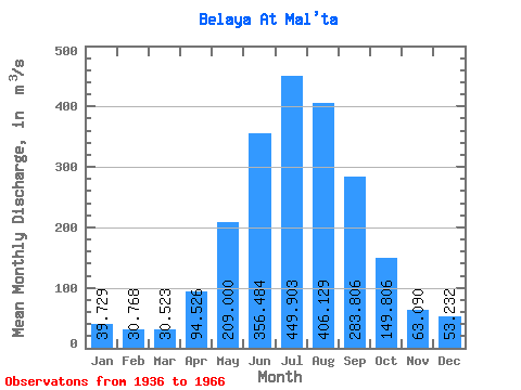
| Statistic | Jan | Feb | Mar | Apr | May | Jun | Jul | Aug | Sep | Oct | Nov | Dec | Annual |
|---|---|---|---|---|---|---|---|---|---|---|---|---|---|
| Mean | 39.73 | 30.77 | 30.52 | 94.53 | 209.00 | 356.48 | 449.90 | 406.13 | 283.81 | 149.81 | 63.09 | 53.23 | 180.58 |
| Standard Deviation | 7.33 | 5.63 | 5.20 | 35.30 | 58.41 | 110.77 | 173.68 | 100.36 | 70.23 | 24.57 | 12.36 | 8.05 | 25.93 |
| Min | 21.10 | 16.30 | 15.80 | 28.10 | 115.00 | 226.00 | 237.00 | 274.00 | 196.00 | 112.00 | 44.50 | 36.20 | 133.95 |
| Max | 50.70 | 41.60 | 40.60 | 175.00 | 369.00 | 615.00 | 997.00 | 639.00 | 511.00 | 201.00 | 88.70 | 67.30 | 246.78 |
| Coefficient of Variation | 0.18 | 0.18 | 0.17 | 0.37 | 0.28 | 0.31 | 0.39 | 0.25 | 0.25 | 0.16 | 0.20 | 0.15 | 0.14 |
 Return to R-Arctic Net Home Page