|
|
|||||||||||||||||
| Point ID: 8176 | Downloads | Plots | Site Data | Code: 8148 |
|
|
|||||||||||||||||
| Download | |
|---|---|
| Site Descriptor Information | Site Time Series Data |
| Link to all available data | |
| View: | Time Series | All |
| Units: | mm |
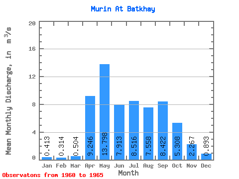
| Statistic | Jan | Feb | Mar | Apr | May | Jun | Jul | Aug | Sep | Oct | Nov | Dec | Annual |
|---|---|---|---|---|---|---|---|---|---|---|---|---|---|
| Mean | 0.41 | 0.31 | 0.50 | 9.25 | 13.80 | 7.91 | 8.52 | 7.56 | 8.42 | 5.31 | 2.27 | 0.89 | 5.80 |
| Standard Deviation | 0.51 | 0.43 | 0.37 | 4.57 | 7.69 | 3.71 | 4.94 | 2.77 | 6.55 | 2.17 | 1.08 | 0.78 | 1.83 |
| Min | 0.01 | 0.00 | 0.00 | 3.86 | 7.60 | 4.76 | 4.10 | 3.83 | 4.14 | 3.07 | 1.15 | 0.27 | 4.53 |
| Max | 1.23 | 1.04 | 0.95 | 16.50 | 25.50 | 13.20 | 14.60 | 11.50 | 21.50 | 8.79 | 4.25 | 2.27 | 8.52 |
| Coefficient of Variation | 1.23 | 1.36 | 0.73 | 0.49 | 0.56 | 0.47 | 0.58 | 0.37 | 0.78 | 0.41 | 0.48 | 0.87 | 0.32 |
 Return to R-Arctic Net Home Page