|
|
|||||||||||||||||
| Point ID: 8164 | Downloads | Plots | Site Data | Code: 8119 |
|
|
|||||||||||||||||
| Download | |
|---|---|
| Site Descriptor Information | Site Time Series Data |
| Link to all available data | |
| View: | Time Series | All |
| Units: | mm |
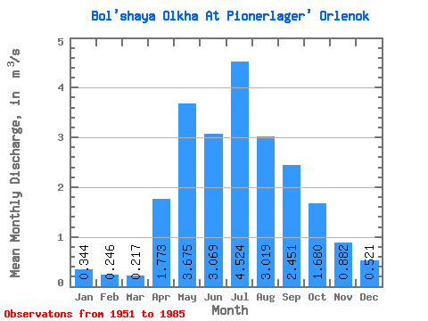
| Statistic | Jan | Feb | Mar | Apr | May | Jun | Jul | Aug | Sep | Oct | Nov | Dec | Annual |
|---|---|---|---|---|---|---|---|---|---|---|---|---|---|
| Mean | 0.34 | 0.25 | 0.22 | 1.77 | 3.67 | 3.07 | 4.52 | 3.02 | 2.45 | 1.68 | 0.88 | 0.52 | 1.88 |
| Standard Deviation | 0.19 | 0.16 | 0.15 | 0.92 | 1.21 | 1.66 | 3.17 | 1.52 | 1.00 | 0.55 | 0.29 | 0.18 | 0.61 |
| Min | 0.04 | 0.02 | 0.02 | 0.46 | 1.87 | 1.51 | 1.42 | 1.11 | 1.33 | 1.09 | 0.44 | 0.25 | 1.17 |
| Max | 0.68 | 0.63 | 0.54 | 3.96 | 5.99 | 7.31 | 11.70 | 6.49 | 4.46 | 2.80 | 1.55 | 0.85 | 3.31 |
| Coefficient of Variation | 0.55 | 0.66 | 0.69 | 0.52 | 0.33 | 0.54 | 0.70 | 0.51 | 0.41 | 0.33 | 0.33 | 0.35 | 0.32 |
 Return to R-Arctic Net Home Page