|
|
|||||||||||||||||
| Point ID: 8161 | Downloads | Plots | Site Data | Code: 8111 |
|
|
|||||||||||||||||
| Download | |
|---|---|
| Site Descriptor Information | Site Time Series Data |
| Link to all available data | |
| View: | Time Series | All |
| Units: | mm |
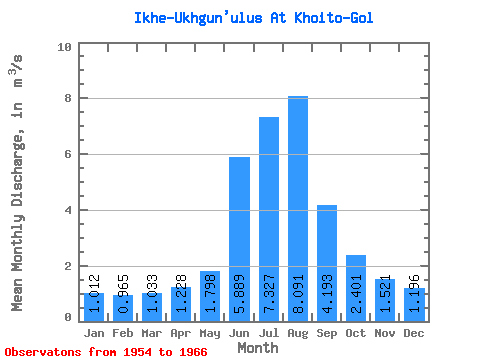
| Statistic | Jan | Feb | Mar | Apr | May | Jun | Jul | Aug | Sep | Oct | Nov | Dec | Annual |
|---|---|---|---|---|---|---|---|---|---|---|---|---|---|
| Mean | 1.01 | 0.96 | 1.03 | 1.23 | 1.80 | 5.89 | 7.33 | 8.09 | 4.19 | 2.40 | 1.52 | 1.20 | 3.02 |
| Standard Deviation | 0.20 | 0.22 | 0.23 | 0.20 | 0.51 | 2.25 | 2.80 | 2.89 | 0.92 | 0.50 | 0.26 | 0.12 | 0.52 |
| Min | 0.59 | 0.44 | 0.55 | 0.89 | 1.27 | 2.91 | 3.86 | 4.29 | 2.92 | 1.77 | 1.26 | 1.00 | 2.37 |
| Max | 1.43 | 1.24 | 1.37 | 1.63 | 2.92 | 11.10 | 11.10 | 15.50 | 6.26 | 3.72 | 2.27 | 1.41 | 3.99 |
| Coefficient of Variation | 0.20 | 0.23 | 0.23 | 0.16 | 0.28 | 0.38 | 0.38 | 0.36 | 0.22 | 0.21 | 0.17 | 0.10 | 0.17 |
 Return to R-Arctic Net Home Page