|
|
|||||||||||||||||
| Point ID: 8137 | Downloads | Plots | Site Data | Code: 7105 |
|
|
|||||||||||||||||
| Download | |
|---|---|
| Site Descriptor Information | Site Time Series Data |
| Link to all available data | |
| View: | Time Series | All |
| Units: | mm |
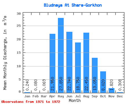
| Statistic | Jan | Feb | Mar | Apr | May | Jun | Jul | Aug | Sep | Oct | Nov | Dec | Annual |
|---|---|---|---|---|---|---|---|---|---|---|---|---|---|
| Mean | 0.24 | 0.08 | 0.07 | 21.95 | 27.85 | 22.74 | 18.75 | 22.45 | 13.05 | 8.02 | 1.82 | 0.31 | 11.44 |
| Standard Deviation | 0.18 | 0.07 | 0.03 | 13.36 | 20.43 | 23.14 | 3.18 | 8.70 | 0.78 | 2.01 | 0.91 | 0.31 | 6.09 |
| Min | 0.11 | 0.03 | 0.05 | 12.50 | 13.40 | 6.38 | 16.50 | 16.30 | 12.50 | 6.60 | 1.18 | 0.09 | 7.14 |
| Max | 0.37 | 0.13 | 0.09 | 31.40 | 42.30 | 39.10 | 21.00 | 28.60 | 13.60 | 9.44 | 2.46 | 0.53 | 15.75 |
| Coefficient of Variation | 0.77 | 0.88 | 0.39 | 0.61 | 0.73 | 1.02 | 0.17 | 0.39 | 0.06 | 0.25 | 0.50 | 1.01 | 0.53 |
 Return to R-Arctic Net Home Page