|
|
|||||||||||||||||
| Point ID: 810 | Downloads | Plots | Site Data | Code: 07OB004 |
|
|
|||||||||||||||||
| Download | |
|---|---|
| Site Descriptor Information | Site Time Series Data |
| Link to all available data | |
| View: | Time Series | All |
| Units: | mm |
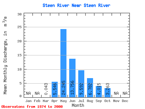
| Statistic | Jan | Feb | Mar | Apr | May | Jun | Jul | Aug | Sep | Oct | Nov | Dec | Annual |
|---|---|---|---|---|---|---|---|---|---|---|---|---|---|
| Mean | 0.04 | 5.55 | 24.25 | 13.76 | 9.59 | 6.78 | 4.01 | 3.26 | |||||
| Standard Deviation | 0.03 | 5.26 | 12.76 | 12.88 | 12.92 | 9.73 | 4.09 | 3.46 | |||||
| Min | 0.00 | 0.04 | 1.04 | 0.66 | 0.09 | 0.02 | 0.01 | 0.08 | |||||
| Max | 0.12 | 21.70 | 45.50 | 44.20 | 44.90 | 47.30 | 13.20 | 15.00 | |||||
| Coefficient of Variation | 0.76 | 0.95 | 0.53 | 0.94 | 1.35 | 1.44 | 1.02 | 1.06 |
 Return to R-Arctic Net Home Page