|
|
|||||||||||||||||
| Point ID: 8095 | Downloads | Plots | Site Data | Code: 1538 |
|
|
|||||||||||||||||
| Download | |
|---|---|
| Site Descriptor Information | Site Time Series Data |
| Link to all available data | |
| View: | Time Series | All |
| Units: | mm |
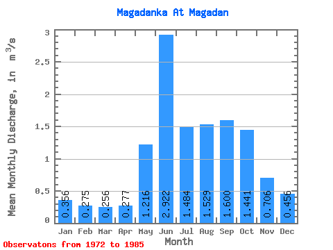
| Statistic | Jan | Feb | Mar | Apr | May | Jun | Jul | Aug | Sep | Oct | Nov | Dec | Annual |
|---|---|---|---|---|---|---|---|---|---|---|---|---|---|
| Mean | 0.36 | 0.28 | 0.26 | 0.28 | 1.22 | 2.92 | 1.48 | 1.53 | 1.60 | 1.44 | 0.71 | 0.46 | 1.04 |
| Standard Deviation | 0.09 | 0.07 | 0.08 | 0.06 | 0.43 | 2.10 | 1.13 | 0.71 | 0.57 | 0.72 | 0.24 | 0.13 | 0.25 |
| Min | 0.19 | 0.13 | 0.10 | 0.18 | 0.48 | 0.76 | 0.64 | 0.67 | 0.60 | 0.44 | 0.34 | 0.24 | 0.67 |
| Max | 0.50 | 0.41 | 0.42 | 0.41 | 1.91 | 7.73 | 4.58 | 2.67 | 2.86 | 3.00 | 1.13 | 0.68 | 1.58 |
| Coefficient of Variation | 0.26 | 0.26 | 0.32 | 0.22 | 0.35 | 0.72 | 0.76 | 0.46 | 0.36 | 0.50 | 0.35 | 0.29 | 0.24 |
 Return to R-Arctic Net Home Page