|
|
|||||||||||||||||
| Point ID: 8081 | Downloads | Plots | Site Data | Code: 1488 |
|
|
|||||||||||||||||
| Download | |
|---|---|
| Site Descriptor Information | Site Time Series Data |
| Link to all available data | |
| View: | Time Series | All |
| Units: | mm |
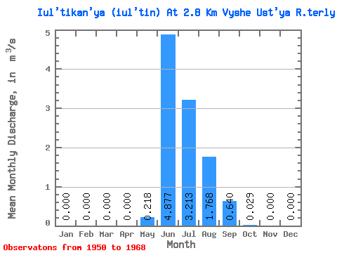
| Statistic | Jan | Feb | Mar | Apr | May | Jun | Jul | Aug | Sep | Oct | Nov | Dec | Annual |
|---|---|---|---|---|---|---|---|---|---|---|---|---|---|
| Mean | 0.00 | 0.00 | 0.00 | 0.00 | 0.22 | 4.88 | 3.21 | 1.77 | 0.64 | 0.03 | 0.00 | 0.00 | 0.90 |
| Standard Deviation | 0.00 | 0.00 | 0.00 | 0.00 | 0.41 | 1.98 | 2.15 | 0.61 | 0.38 | 0.05 | 0.00 | 0.00 | 0.26 |
| Min | 0.00 | 0.00 | 0.00 | 0.00 | 0.00 | 1.33 | 0.88 | 0.88 | 0.10 | 0.00 | 0.00 | 0.00 | 0.42 |
| Max | 0.00 | 0.00 | 0.00 | 0.00 | 1.65 | 7.65 | 9.80 | 3.54 | 1.28 | 0.18 | 0.00 | 0.00 | 1.38 |
| Coefficient of Variation | 1.89 | 0.41 | 0.67 | 0.35 | 0.60 | 1.60 | 4.12 | 0.28 |
 Return to R-Arctic Net Home Page