|
|
|||||||||||||||||
| Point ID: 8080 | Downloads | Plots | Site Data | Code: 1452 |
|
|
|||||||||||||||||
| Download | |
|---|---|
| Site Descriptor Information | Site Time Series Data |
| Link to all available data | |
| View: | Time Series | All |
| Units: | mm |
| Statistic | Jan | Feb | Mar | Apr | May | Jun | Jul | Aug | Sep | Oct | Nov | Dec | Annual |
|---|---|---|---|---|---|---|---|---|---|---|---|---|---|
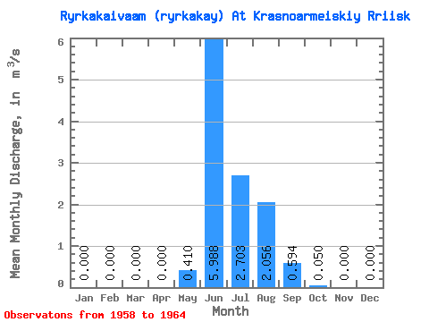
| Mean | 0.00 | 0.00 | 0.00 | 0.00 | 0.41 | 5.99 | 2.70 | 2.06 | 0.59 | 0.05 | 0.00 | 0.00 | 0.94 |
| Standard Deviation | 0.00 | 0.00 | 0.00 | 0.00 | 0.56 | 2.74 | 1.57 | 1.37 | 0.43 | 0.04 | 0.00 | 0.00 | 0.37 |
| Min | 0.00 | 0.00 | 0.00 | 0.00 | 0.00 | 3.51 | 1.56 | 0.90 | 0.10 | 0.01 | 0.00 | 0.00 | 0.56 |
| Max | 0.00 | 0.00 | 0.00 | 0.00 | 1.52 | 10.00 | 5.44 | 4.72 | 1.39 | 0.14 | 0.00 | 0.00 | 1.43 |
| Coefficient of Variation | 1.35 | 0.46 | 0.58 | 0.67 | 0.72 | 0.90 | 0.39 |
 Return to R-Arctic Net Home Page