|
|
|||||||||||||||||
| Point ID: 8076 | Downloads | Plots | Site Data | Code: 1423 |
|
|
|||||||||||||||||
| Download | |
|---|---|
| Site Descriptor Information | Site Time Series Data |
| Link to all available data | |
| View: | Time Series | All |
| Units: | mm |
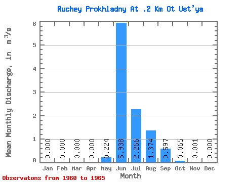
| Statistic | Jan | Feb | Mar | Apr | May | Jun | Jul | Aug | Sep | Oct | Nov | Dec | Annual |
|---|---|---|---|---|---|---|---|---|---|---|---|---|---|
| Mean | 0.00 | 0.00 | 0.00 | 0.00 | 0.22 | 5.94 | 2.27 | 1.37 | 0.60 | 0.07 | 0.00 | 0.00 | 0.88 |
| Standard Deviation | 0.00 | 0.00 | 0.00 | 0.00 | 0.35 | 1.93 | 1.84 | 0.52 | 0.59 | 0.05 | 0.00 | 0.00 | 0.21 |
| Min | 0.00 | 0.00 | 0.00 | 0.00 | 0.00 | 3.51 | 0.99 | 0.64 | 0.21 | 0.01 | 0.00 | 0.00 | 0.64 |
| Max | 0.00 | 0.00 | 0.00 | 0.00 | 0.84 | 8.11 | 5.52 | 1.80 | 1.73 | 0.13 | 0.00 | 0.00 | 1.10 |
| Coefficient of Variation | 1.57 | 0.33 | 0.81 | 0.38 | 0.99 | 0.79 | 2.24 | 0.24 |
 Return to R-Arctic Net Home Page