|
|
|||||||||||||||||
| Point ID: 8066 | Downloads | Plots | Site Data | Code: 1351 |
|
|
|||||||||||||||||
| Download | |
|---|---|
| Site Descriptor Information | Site Time Series Data |
| Link to all available data | |
| View: | Time Series | All |
| Units: | mm |
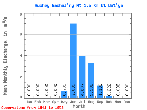
| Statistic | Jan | Feb | Mar | Apr | May | Jun | Jul | Aug | Sep | Oct | Nov | Dec | Annual |
|---|---|---|---|---|---|---|---|---|---|---|---|---|---|
| Mean | 0.00 | 0.00 | 0.00 | 0.00 | 0.70 | 7.01 | 4.01 | 3.30 | 1.20 | 0.22 | 0.01 | 0.00 | 1.35 |
| Standard Deviation | 0.00 | 0.00 | 0.00 | 0.00 | 0.86 | 2.96 | 1.67 | 1.11 | 0.74 | 0.18 | 0.01 | 0.00 | 0.40 |
| Min | 0.00 | 0.00 | 0.00 | 0.00 | 0.00 | 3.19 | 1.62 | 1.84 | 0.46 | 0.03 | 0.00 | 0.00 | 0.80 |
| Max | 0.00 | 0.00 | 0.00 | 0.00 | 2.61 | 13.30 | 6.38 | 5.71 | 2.59 | 0.55 | 0.03 | 0.00 | 2.00 |
| Coefficient of Variation | 1.21 | 0.42 | 0.42 | 0.34 | 0.62 | 0.81 | 1.23 | 0.30 |
 Return to R-Arctic Net Home Page