|
|
|||||||||||||||||
| Point ID: 8063 | Downloads | Plots | Site Data | Code: 1298 |
|
|
|||||||||||||||||
| Download | |
|---|---|
| Site Descriptor Information | Site Time Series Data |
| Link to all available data | |
| View: | Time Series | All |
| Units: | mm |
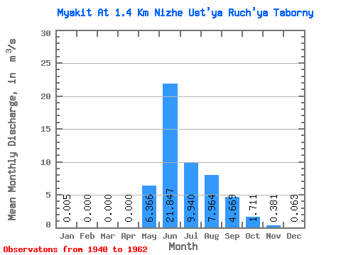
| Statistic | Jan | Feb | Mar | Apr | May | Jun | Jul | Aug | Sep | Oct | Nov | Dec | Annual |
|---|---|---|---|---|---|---|---|---|---|---|---|---|---|
| Mean | 0.01 | 0.00 | 0.00 | 0.00 | 6.37 | 21.85 | 9.94 | 7.96 | 4.67 | 1.71 | 0.38 | 0.06 | 4.40 |
| Standard Deviation | 0.01 | 0.00 | 0.00 | 0.00 | 4.35 | 10.65 | 4.12 | 4.32 | 2.69 | 0.79 | 0.18 | 0.07 | 1.11 |
| Min | 0.00 | 0.00 | 0.00 | 0.00 | 0.21 | 7.71 | 3.74 | 2.77 | 1.94 | 0.84 | 0.07 | 0.00 | 2.44 |
| Max | 0.05 | 0.00 | 0.00 | 0.00 | 16.50 | 42.30 | 16.60 | 18.40 | 14.70 | 3.94 | 0.82 | 0.21 | 6.24 |
| Coefficient of Variation | 2.60 | 4.36 | 3.39 | 0.68 | 0.49 | 0.41 | 0.54 | 0.57 | 0.46 | 0.48 | 1.12 | 0.25 |
 Return to R-Arctic Net Home Page