|
|
|||||||||||||||||
| Point ID: 8017 | Downloads | Plots | Site Data | Code: 3850 |
|
|
|||||||||||||||||
| Download | |
|---|---|
| Site Descriptor Information | Site Time Series Data |
| Link to all available data | |
| View: | Time Series | All |
| Units: | mm |
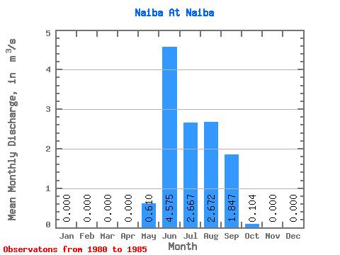
| Statistic | Jan | Feb | Mar | Apr | May | Jun | Jul | Aug | Sep | Oct | Nov | Dec | Annual |
|---|---|---|---|---|---|---|---|---|---|---|---|---|---|
| Mean | 0.00 | 0.00 | 0.00 | 0.00 | 0.61 | 4.58 | 2.67 | 2.67 | 1.85 | 0.10 | 0.00 | 0.00 | 1.04 |
| Standard Deviation | 0.00 | 0.00 | 0.00 | 0.00 | 1.20 | 1.66 | 1.30 | 1.13 | 0.97 | 0.13 | 0.00 | 0.00 | 0.20 |
| Min | 0.00 | 0.00 | 0.00 | 0.00 | 0.00 | 2.46 | 0.80 | 0.52 | 0.66 | 0.00 | 0.00 | 0.00 | 0.74 |
| Max | 0.00 | 0.00 | 0.00 | 0.00 | 3.01 | 7.37 | 4.51 | 3.64 | 2.74 | 0.29 | 0.00 | 0.00 | 1.26 |
| Coefficient of Variation | 1.97 | 0.36 | 0.49 | 0.42 | 0.53 | 1.24 | 0.19 |
 Return to R-Arctic Net Home Page