|
|
|||||||||||||||||
| Point ID: 7977 | Downloads | Plots | Site Data | Code: 3619 |
|
|
|||||||||||||||||
| Download | |
|---|---|
| Site Descriptor Information | Site Time Series Data |
| Link to all available data | |
| View: | Time Series | All |
| Units: | mm |
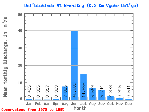
| Statistic | Jan | Feb | Mar | Apr | May | Jun | Jul | Aug | Sep | Oct | Nov | Dec | Annual |
|---|---|---|---|---|---|---|---|---|---|---|---|---|---|
| Mean | 0.46 | 0.35 | 0.32 | 0.37 | 7.87 | 40.01 | 14.86 | 6.67 | 5.74 | 2.37 | 0.92 | 0.64 | 6.76 |
| Standard Deviation | 0.13 | 0.11 | 0.09 | 0.19 | 5.36 | 8.12 | 9.08 | 2.45 | 2.48 | 0.95 | 0.30 | 0.23 | 1.41 |
| Min | 0.29 | 0.22 | 0.19 | 0.18 | 1.74 | 26.90 | 5.23 | 3.13 | 1.60 | 0.73 | 0.49 | 0.38 | 5.30 |
| Max | 0.68 | 0.61 | 0.49 | 0.78 | 18.30 | 52.40 | 35.80 | 9.45 | 9.94 | 3.89 | 1.43 | 1.15 | 9.66 |
| Coefficient of Variation | 0.28 | 0.31 | 0.29 | 0.52 | 0.68 | 0.20 | 0.61 | 0.37 | 0.43 | 0.40 | 0.33 | 0.35 | 0.21 |
 Return to R-Arctic Net Home Page