|
|
|||||||||||||||||
| Point ID: 7975 | Downloads | Plots | Site Data | Code: 3616 |
|
|
|||||||||||||||||
| Download | |
|---|---|
| Site Descriptor Information | Site Time Series Data |
| Link to all available data | |
| View: | Time Series | All |
| Units: | mm |
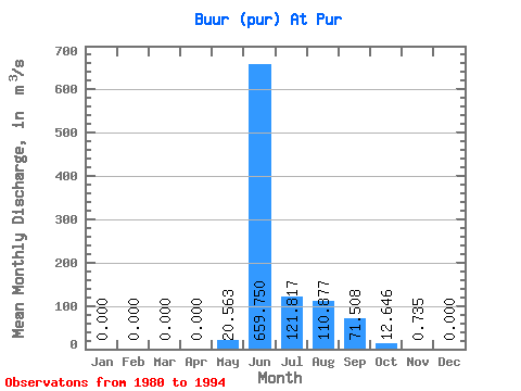
| Statistic | Jan | Feb | Mar | Apr | May | Jun | Jul | Aug | Sep | Oct | Nov | Dec | Annual |
|---|---|---|---|---|---|---|---|---|---|---|---|---|---|
| Mean | 0.00 | 0.00 | 0.00 | 0.00 | 20.56 | 659.75 | 121.82 | 110.88 | 71.51 | 12.65 | 0.73 | 0.00 | 70.76 |
| Standard Deviation | 0.00 | 0.00 | 0.00 | 0.00 | 35.15 | 204.84 | 104.31 | 98.71 | 54.43 | 12.05 | 0.71 | 0.00 | 17.30 |
| Min | 0.00 | 0.00 | 0.00 | 0.00 | 0.00 | 273.00 | 21.40 | 14.40 | 14.90 | 2.33 | 0.00 | 0.00 | 53.19 |
| Max | 0.00 | 0.00 | 0.00 | 0.00 | 97.90 | 984.00 | 416.00 | 354.00 | 207.00 | 40.10 | 2.24 | 0.00 | 93.74 |
| Coefficient of Variation | 1.71 | 0.31 | 0.86 | 0.89 | 0.76 | 0.95 | 0.97 | 0.24 |
 Return to R-Arctic Net Home Page