|
|
|||||||||||||||||
| Point ID: 7970 | Downloads | Plots | Site Data | Code: 3611 |
|
|
|||||||||||||||||
| Download | |
|---|---|
| Site Descriptor Information | Site Time Series Data |
| Link to all available data | |
| View: | Time Series | All |
| Units: | mm |
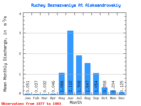
| Statistic | Jan | Feb | Mar | Apr | May | Jun | Jul | Aug | Sep | Oct | Nov | Dec | Annual |
|---|---|---|---|---|---|---|---|---|---|---|---|---|---|
| Mean | 0.05 | 0.04 | 0.03 | 0.05 | 1.07 | 3.11 | 1.91 | 1.55 | 1.05 | 0.36 | 0.20 | 0.12 | 0.84 |
| Standard Deviation | 0.04 | 0.04 | 0.03 | 0.04 | 0.21 | 1.15 | 0.75 | 1.01 | 0.38 | 0.11 | 0.12 | 0.10 | 0.21 |
| Min | 0.00 | 0.00 | 0.00 | 0.00 | 0.83 | 0.96 | 0.96 | 0.51 | 0.39 | 0.20 | 0.07 | 0.01 | 0.54 |
| Max | 0.11 | 0.10 | 0.07 | 0.10 | 1.35 | 4.32 | 3.03 | 3.12 | 1.49 | 0.48 | 0.35 | 0.26 | 1.05 |
| Coefficient of Variation | 0.87 | 1.10 | 0.98 | 0.90 | 0.20 | 0.37 | 0.39 | 0.65 | 0.36 | 0.30 | 0.60 | 0.79 | 0.25 |
 Return to R-Arctic Net Home Page