|
|
|||||||||||||||||
| Point ID: 7949 | Downloads | Plots | Site Data | Code: 3585 |
|
|
|||||||||||||||||
| Download | |
|---|---|
| Site Descriptor Information | Site Time Series Data |
| Link to all available data | |
| View: | Time Series | All |
| Units: | mm |
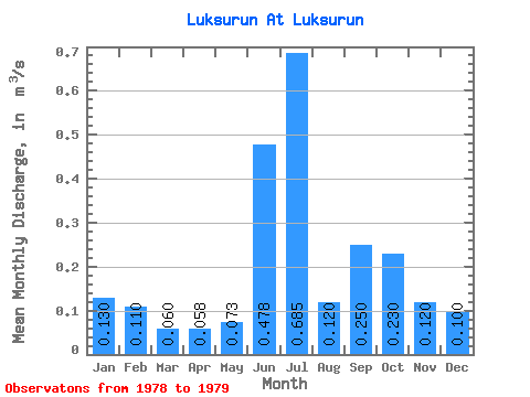
| Statistic | Jan | Feb | Mar | Apr | May | Jun | Jul | Aug | Sep | Oct | Nov | Dec | Annual |
|---|---|---|---|---|---|---|---|---|---|---|---|---|---|
| Mean | 0.13 | 0.11 | 0.06 | 0.06 | 0.07 | 0.48 | 0.69 | 0.12 | 0.25 | 0.23 | 0.12 | 0.10 | 0.14 |
| Standard Deviation | 0.56 | 0.67 | 0.01 | 0.20 | |||||||||
| Min | 0.13 | 0.11 | 0.06 | 0.06 | 0.07 | 0.09 | 0.21 | 0.11 | 0.11 | 0.23 | 0.12 | 0.10 | 0.14 |
| Max | 0.13 | 0.11 | 0.06 | 0.06 | 0.07 | 0.87 | 1.16 | 0.13 | 0.39 | 0.23 | 0.12 | 0.10 | 0.14 |
| Coefficient of Variation | 1.16 | 0.98 | 0.12 | 0.79 |
 Return to R-Arctic Net Home Page