|
|
|||||||||||||||||
| Point ID: 7946 | Downloads | Plots | Site Data | Code: 3582 |
|
|
|||||||||||||||||
| Download | |
|---|---|
| Site Descriptor Information | Site Time Series Data |
| Link to all available data | |
| View: | Time Series | All |
| Units: | mm |
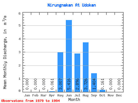
| Statistic | Jan | Feb | Mar | Apr | May | Jun | Jul | Aug | Sep | Oct | Nov | Dec | Annual |
|---|---|---|---|---|---|---|---|---|---|---|---|---|---|
| Mean | 0.00 | 0.00 | 0.00 | 0.06 | 3.01 | 5.42 | 2.90 | 3.73 | 1.40 | 0.16 | 0.00 | 0.00 | 1.59 |
| Standard Deviation | 0.00 | 0.00 | 0.00 | 0.06 | 3.27 | 3.04 | 2.54 | 5.53 | 0.51 | 0.23 | 0.00 | 0.00 | 1.00 |
| Min | 0.00 | 0.00 | 0.00 | 0.00 | 0.88 | 0.83 | 0.40 | 0.08 | 0.59 | 0.00 | 0.00 | 0.00 | 0.68 |
| Max | 0.00 | 0.00 | 0.00 | 0.14 | 14.00 | 12.20 | 9.76 | 22.10 | 2.44 | 0.83 | 0.00 | 0.00 | 3.64 |
| Coefficient of Variation | 0.97 | 1.09 | 0.56 | 0.88 | 1.48 | 0.37 | 1.41 | 0.63 |
 Return to R-Arctic Net Home Page