|
|
|||||||||||||||||
| Point ID: 794 | Downloads | Plots | Site Data | Code: 07JD002 |
|
|
|||||||||||||||||
| Download | |
|---|---|
| Site Descriptor Information | Site Time Series Data |
| Link to all available data | |
| View: | Time Series | All |
| Units: | mm |
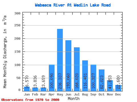
| Statistic | Jan | Feb | Mar | Apr | May | Jun | Jul | Aug | Sep | Oct | Nov | Dec | Annual |
|---|---|---|---|---|---|---|---|---|---|---|---|---|---|
| Mean | 16.57 | 13.84 | 13.66 | 100.09 | 236.34 | 193.06 | 166.02 | 116.48 | 100.33 | 82.02 | 41.85 | 22.68 | 92.85 |
| Standard Deviation | 10.86 | 8.60 | 7.72 | 84.01 | 174.51 | 169.36 | 130.80 | 101.14 | 103.34 | 86.01 | 36.01 | 15.24 | 55.56 |
| Min | 1.57 | 1.35 | 1.66 | 19.40 | 22.50 | 11.20 | 10.00 | 6.02 | 6.07 | 7.10 | 4.02 | 2.81 | 9.45 |
| Max | 44.30 | 38.00 | 31.40 | 478.00 | 726.00 | 799.00 | 567.00 | 413.00 | 391.00 | 432.00 | 160.00 | 56.40 | 248.46 |
| Coefficient of Variation | 0.66 | 0.62 | 0.57 | 0.84 | 0.74 | 0.88 | 0.79 | 0.87 | 1.03 | 1.05 | 0.86 | 0.67 | 0.60 |
 Return to R-Arctic Net Home Page