|
|
|||||||||||||||||
| Point ID: 793 | Downloads | Plots | Site Data | Code: 07JD001 |
|
|
|||||||||||||||||
| Download | |
|---|---|
| Site Descriptor Information | Site Time Series Data |
| Link to all available data | |
| View: | Time Series | All |
| Units: | mm |
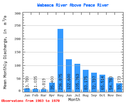
| Statistic | Jan | Feb | Mar | Apr | May | Jun | Jul | Aug | Sep | Oct | Nov | Dec | Annual |
|---|---|---|---|---|---|---|---|---|---|---|---|---|---|
| Mean | 13.78 | 11.04 | 9.82 | 35.40 | 236.88 | 122.60 | 105.76 | 83.17 | 72.74 | 65.51 | 54.78 | 33.17 | 53.05 |
| Standard Deviation | 9.39 | 7.34 | 6.22 | 20.00 | 117.93 | 47.20 | 87.07 | 70.86 | 48.41 | 40.51 | 38.40 | 27.22 | 14.94 |
| Min | 2.63 | 2.21 | 3.21 | 10.50 | 99.50 | 71.80 | 38.30 | 21.60 | 31.50 | 25.00 | 13.20 | 6.14 | 36.57 |
| Max | 25.70 | 20.50 | 18.90 | 59.20 | 374.00 | 198.00 | 314.00 | 239.00 | 183.00 | 126.00 | 106.00 | 73.50 | 65.71 |
| Coefficient of Variation | 0.68 | 0.67 | 0.63 | 0.56 | 0.50 | 0.39 | 0.82 | 0.85 | 0.67 | 0.62 | 0.70 | 0.82 | 0.28 |
 Return to R-Arctic Net Home Page