|
|
|||||||||||||||||
| Point ID: 7929 | Downloads | Plots | Site Data | Code: 3516 |
|
|
|||||||||||||||||
| Download | |
|---|---|
| Site Descriptor Information | Site Time Series Data |
| Link to all available data | |
| View: | Time Series | All |
| Units: | mm |
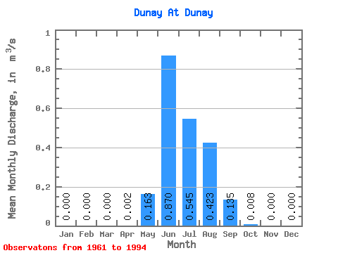
| Statistic | Jan | Feb | Mar | Apr | May | Jun | Jul | Aug | Sep | Oct | Nov | Dec | Annual |
|---|---|---|---|---|---|---|---|---|---|---|---|---|---|
| Mean | 0.00 | 0.00 | 0.00 | 0.00 | 0.16 | 0.87 | 0.55 | 0.42 | 0.14 | 0.01 | 0.00 | 0.00 | 0.18 |
| Standard Deviation | 0.00 | 0.00 | 0.00 | 0.00 | 0.14 | 0.35 | 0.20 | 0.23 | 0.11 | 0.02 | 0.00 | 0.00 | 0.05 |
| Min | 0.00 | 0.00 | 0.00 | 0.00 | 0.01 | 0.27 | 0.14 | 0.07 | 0.01 | 0.00 | 0.00 | 0.00 | 0.11 |
| Max | 0.00 | 0.00 | 0.00 | 0.01 | 0.56 | 1.68 | 0.92 | 0.87 | 0.43 | 0.09 | 0.00 | 0.00 | 0.29 |
| Coefficient of Variation | 1.62 | 0.86 | 0.40 | 0.37 | 0.54 | 0.84 | 2.08 | 0.26 |
 Return to R-Arctic Net Home Page