|
|
|||||||||||||||||
| Point ID: 7920 | Downloads | Plots | Site Data | Code: 3498 |
|
|
|||||||||||||||||
| Download | |
|---|---|
| Site Descriptor Information | Site Time Series Data |
| Link to all available data | |
| View: | Time Series | All |
| Units: | mm |
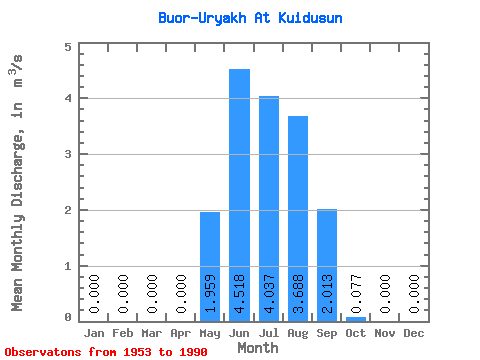
| Statistic | Jan | Feb | Mar | Apr | May | Jun | Jul | Aug | Sep | Oct | Nov | Dec | Annual |
|---|---|---|---|---|---|---|---|---|---|---|---|---|---|
| Mean | 0.00 | 0.00 | 0.00 | 0.00 | 1.96 | 4.52 | 4.04 | 3.69 | 2.01 | 0.08 | 0.00 | 0.00 | 1.33 |
| Standard Deviation | 0.00 | 0.00 | 0.00 | 0.00 | 2.34 | 4.72 | 3.67 | 3.38 | 2.30 | 0.09 | 0.00 | 0.00 | 0.78 |
| Min | 0.00 | 0.00 | 0.00 | 0.00 | 0.00 | 0.04 | 0.40 | 0.25 | 0.13 | 0.00 | 0.00 | 0.00 | 0.40 |
| Max | 0.00 | 0.00 | 0.00 | 0.00 | 9.58 | 19.90 | 13.50 | 13.80 | 9.26 | 0.34 | 0.00 | 0.00 | 3.13 |
| Coefficient of Variation | 1.20 | 1.04 | 0.91 | 0.92 | 1.14 | 1.11 | 0.59 |
 Return to R-Arctic Net Home Page